Doing the Tateyama Kurobe Alpine Route as a same-day Toyama-to-Nagano sprint is the worst way to experience it. I’ve watched the buses load and unload in choreographed convoys; I’ve seen tour groups march across Kurobe Dam with thirty minutes for the photo and the souvenir stand combined. The route fits in a day. It just shouldn’t.
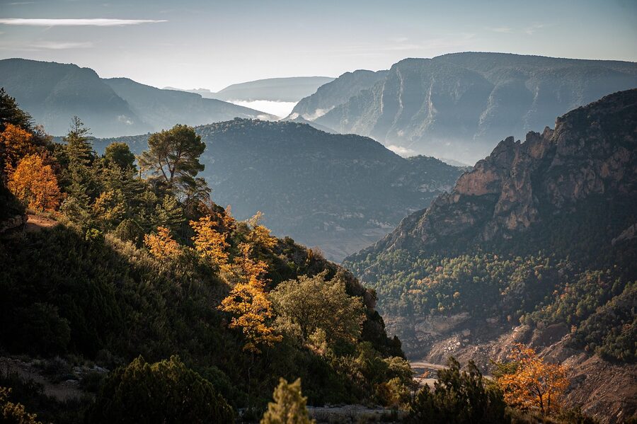
What you miss when you race the schedule: the snow corridor in the soft 07:00 light before the day’s first tour groups arrive at Murodo, the Tateyama Sugi cedar grove on the cable-car descent (some of those trees are over a thousand years old, and the bus driver says nothing about them), the Kurobe Dam observation deck reached by the 220-step climb that group itineraries skip on principle, and the Mikurigaike pond in the late afternoon when the wind drops and the crater lake mirrors the entire ridge. None of this is on the day-traverse itinerary. All of it is the reason the route exists.
The fix is simple: stay overnight on the mountain. Hotel Tateyama at Murodo, 2,450 metres up, is the highest hotel in Japan. There’s also Mikurigaike Onsen ten minutes’ walk from the terminal, plus the Hotel Tateyama-affiliated Midagahara Hotel a few stops below. One night up there changes the whole experience. Two nights, with a proper Kurobe Dam morning included, is the version I’d actually recommend.
One serious caveat to flag first, because it changes the calculus for anyone planning a 2026 or 2027 trip. Hotel Tateyama’s lodging service is closing on 31 August 2026. The official statement is on the hotel’s site. The day-trip experience of stepping off the trolleybus and walking the snow corridor doesn’t change. The overnight option at Murodo, in the form most travellers know it, ends after the 2026 summer season. If staying up there is on your list, the window is now.
In This Article
- The route, plainly: from Toyama to Shinano-Omachi
- Quick comparison: day-traverse vs overnight
- When to come: the snow corridor window
- Toyama Chiho Railway: the leg most articles forget
- Tateyama Cable Car and Bijodaira: the Tateyama Sugi cedars
- Highland Bus and the snow corridor at Murodo
- Murodo plateau: the part that earns the overnight
- Where to stay at Murodo (while you still can)
- Trolleybus to Daikanbo and the Tateyama Ropeway
- Kurobe Cable Car and the Kurobeko approach
- Kurobe Dam: 220 steps, then the discharge
- The Nagano-side exit: Kanden bus and the bus to Shinano-Omachi
- The Kurobe Gorge Railway add-on: a different mountain
- Mikurigaike, Jigokudani and the day-2 walking
- Shomyo Falls: the side trip Toyama side
- What to wear: the temperature differential is the catch
- Tickets and reservations: the Web Ticket question
- Combining with the rest of Hokuriku
- What I’d actually do: a 3-day plan that earns its name
- The closing notes nobody mentions
The route, plainly: from Toyama to Shinano-Omachi
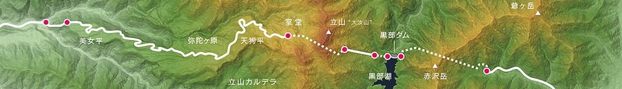
The Tateyama Kurobe Alpine Route is a 37.2 km mountain crossing between Toyama Prefecture and Nagano Prefecture, opened on 1 June 1971 and now in its 55th season. The route is closed to private vehicles between Tateyama Station and Ogizawa, which is why you do it on a chain of eight different vehicles instead of a single drive. The route runs annually from 15 April to 30 November; outside that window the access roads close for snow.
From Toyama eastbound, the legs are: Toyama Chiho Railway from Dentetsu Toyama to Tateyama (about 1 hour, ¥1,420), Tateyama Cable Car to Bijodaira (7 minutes, ¥1,090), Tateyama Highland Bus to Murodo (50 minutes, ¥3,000), Tateyama Tunnel Trolleybus to Daikanbo (10 minutes, ¥2,200), Tateyama Ropeway to Kurobedaira (7 minutes, ¥1,700), Kurobe Cable Car to Kurobeko (5 minutes, ¥1,150), a 15-minute walk across Kurobe Dam, the Kanden Tunnel Electric Bus to Ogizawa (16 minutes, ¥1,800), and an Ogizawa-Omachi line bus from Ogizawa to Shinano-Omachi station (40 minutes, ¥1,650). All fares above are official figures published on alpen-route.com as of February 2026.
A one-way ticket from Dentetsu Toyama to Ogizawa costs ¥10,530; including the bus continuation to Shinano-Omachi it’s ¥11,920. The ticket is valid for five consecutive days, which is the structural permission slip for breaking up the day.
Quick comparison: day-traverse vs overnight
| Style | Time | One-way fare | What you get | What you miss |
|---|---|---|---|---|
| Day traverse, Toyama to Shinano-Omachi | 6–7 hrs on the route | ¥11,920 | Every vehicle, the snow corridor stop, the dam crossing | Early-morning Murodo, evening Kurobe Dam, the Mikurigaike walking trail, the cedar grove on foot |
| Overnight at Murodo, one night | Two days | ¥11,920 + lodging from ¥31,900 | The plateau in the empty pre-09:00 hour, sunset and stars at 2,450m, Mikurigaike at dusk | The morning dam-discharge view if you continue Toyama-side |
| Overnight at Kurobeko / Omachi Onsen, one night | Two days | ¥11,920 + lodging | Dam observation deck and Kurobe Damsite Restaurant in the morning, no rush across the bridge | The Murodo plateau experience above 2,000m |
| Two nights, one each side | Three days | ¥11,920 + lodging | Both ends, plus enough buffer for weather | Nothing the route offers |
The fares are identical across the four options because the through-ticket is the same and the legs don’t change. What scales is how much you actually see for it.
When to come: the snow corridor window
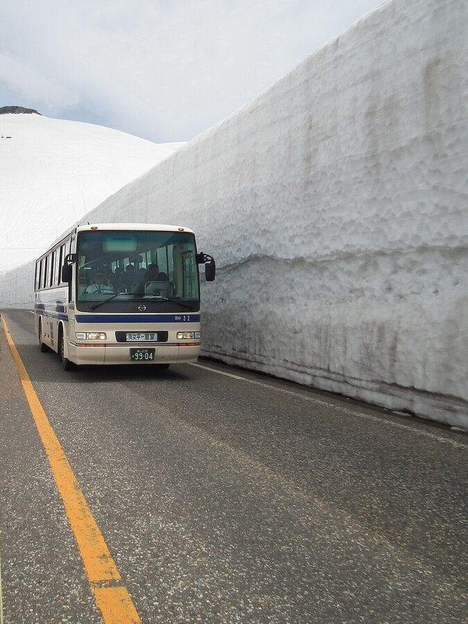
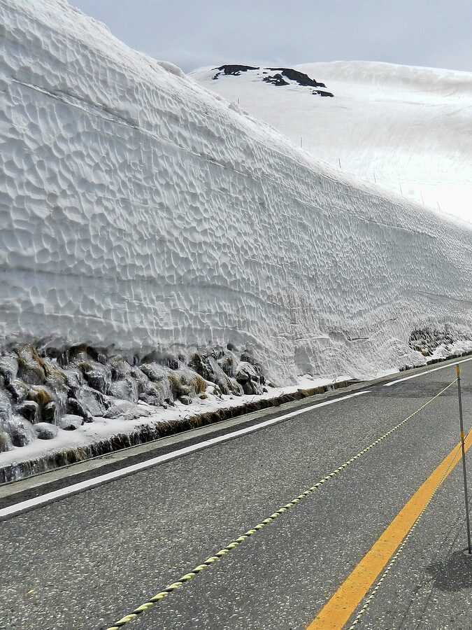
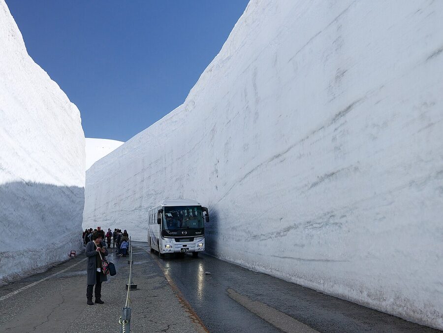
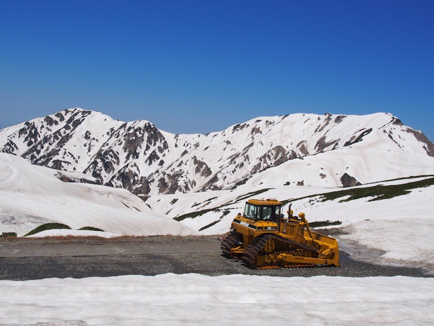
The route’s signature spectacle is the Yuki-no-Otani, the snow corridor cut through the snowpack on the Tateyama Highland Bus road approaching Murodo. Snowploughs cut the access road each spring; the snow walls left on either side reach 17 metres at peak years (occasionally 20m, when the previous winter has been particularly heavy). A dedicated walking section, roughly 500 metres long, is open to pedestrians from mid-April to around 25 June each year. Outside those dates you can still see the walls from the bus window for a few weeks longer, but the walking strip itself is fenced off as the snow softens.
For 2026 the route reopens to the snow corridor on 15 April, the same date as the full traverse. The walking section dates run from 15 April to around 25 June (the official closing date varies year to year depending on melt). If the snow walls are the reason you’re going, late April through mid-May is the safe window: the walls are still 15m+ high, the weather is more reliably clear than April, and the access road is fully open without weather-related closures that early-season Murodo sometimes triggers.
The other seasonal pivots:
- Mid-June to late August: alpine flowers across Murodo plateau, Mikurigaike snow-free from July onwards. Hiking weather. The dam discharge is on (more on that below).
- Late September to mid-October: autumn colour, starting at Murodo and Daikanbo and descending the slopes through October. The Murodo–Daikanbo segment is the strongest colour viewing on the route.
- Mid-October to late November: clear cold light, snow already returning to the upper plateau, fewer visitors, the lower-elevation cedar forest still yellow-gold.
- 1 December to 14 April: closed. No exceptions, no ski-touring access to the upper sections.
Toyama Chiho Railway: the leg most articles forget
From JR Toyama Station, the Toyama Chiho Railway (the local operator, often shortened to Chitetsu) takes you to Tateyama Station in roughly an hour. Dentetsu Toyama is a 1-minute walk from JR Toyama, signposted from the south exit. The fare is ¥1,420 one way, paid on board or via the Tateyama-Kurobe Alpine route through-ticket. Train frequency is once or twice an hour, dropping to hourly outside peak season; check the timetable on chitetsu.co.jp before heading down.
This is the route leg almost every English-language article condenses into a sentence. It’s worth more than that. The Chitetsu Tateyama Line runs through the river-valley apron of the Tateyama foothills, past rice fields and small unmanned stations, and on a clear day the Tateyama range fills the windscreen as you climb. Sit on the right-hand side eastbound (left, going back). It’s the leg I’d most happily redo as a stand-alone trip, with a stop in Iwakuraji or one of the other small valley towns along the way.
If you’re coming from Tokyo, the chain is: Hokuriku Shinkansen Tokyo to Toyama, about 2h 12m and fully covered by the Japan Rail Pass; transfer at Toyama Station to Dentetsu Toyama. The Hokuriku Arch Pass and the JR West regional pass on the JR West pass guide both cover the shinkansen leg into Toyama, but neither covers the route itself.
Tateyama Cable Car and Bijodaira: the Tateyama Sugi cedars
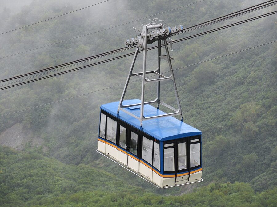
The Tateyama Cable Car is the funicular that lifts you from Tateyama (475m) to Bijodaira (977m). Seven minutes, ¥1,090, departures roughly every 20 minutes during the operating season. The line was built as part of the original 1971 route and uses two cars on a single counterweighted track, so you’ll pass the descending car at the midpoint. The capacity of 130 per car is the route’s first major bottleneck: in late April through early May, the wait at Tateyama Station can stretch to two hours if you arrive without an advance Web Ticket reservation. Reserve the cable car slot online at alpen-route.com Web Ticket; it’s the single most useful planning step for the Toyama-side start.
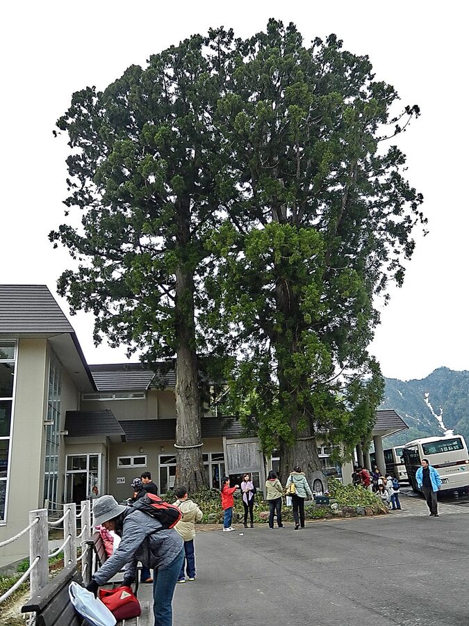
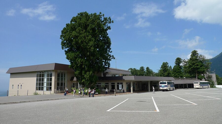
Bijodaira is where the Tateyama Sugi cedar forest starts. Some of the cedars here are over a thousand years old; a few have hollowed-out trunks you can step inside. The rest of the route is engineered transit between viewpoints; this is the only stop where ancient temperate forest is part of the experience. There’s a 30-minute interpretive footpath loop signposted from the station building, and the trees are visible from the Highland Bus on the climb to Murodo, but you don’t get to stop. The day-traverse cost of skipping Bijodaira on foot is the entire forest layer of the journey.
Highland Bus and the snow corridor at Murodo
The Tateyama Highland Bus runs from Bijodaira to Murodo in 50 minutes, climbing 1,473 metres of vertical to top out at 2,450m. The fare is ¥3,000 one way. The bus has occasional photo stops at Midagahara (a wetland plateau halfway up) and at the snow corridor approach, but they’re brief, in a moving convoy of buses, and the driver doesn’t wait. The route from Bijodaira spirals up through the cedar forest, then breaks above the treeline into open subalpine terrain.
The snow corridor itself is the bit everyone remembers. Coming up by bus in late April through May, the road tunnels between two walls of snow that the ploughs have left behind. The walls catch direct sunlight on the upper face and stay shadowed in their trough, so on a sunny day the contrast between the bright-white walls and the ribbon of clear blue sky overhead is the postcard image of the entire route. It is, properly, the visible record of how much snow falls on this part of the Northern Alps; in the heaviest winters the walls reach 20 metres, in lean ones they top out around 13.
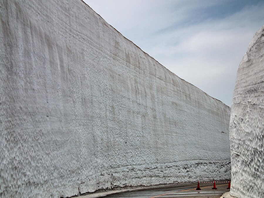
The walking section, the one with the people-shaped silhouettes against the snow walls in every guidebook, is signposted from Murodo terminal. Walk out of the building, follow the signs to Yuki-no-Otani, and the strip opens up about 100 metres ahead. The walk is roughly 500 metres each way, easy underfoot (cleared and gritted), and takes 20 minutes including the inevitable photographs. The catch: this is where the day-tour buses converge at 11:00 and again at 13:30. Either get there in the 09:30 first hour of operation, or wait until the 15:00 lull. Otherwise you’re queuing for the same patch of snow wall everyone else is queuing for.
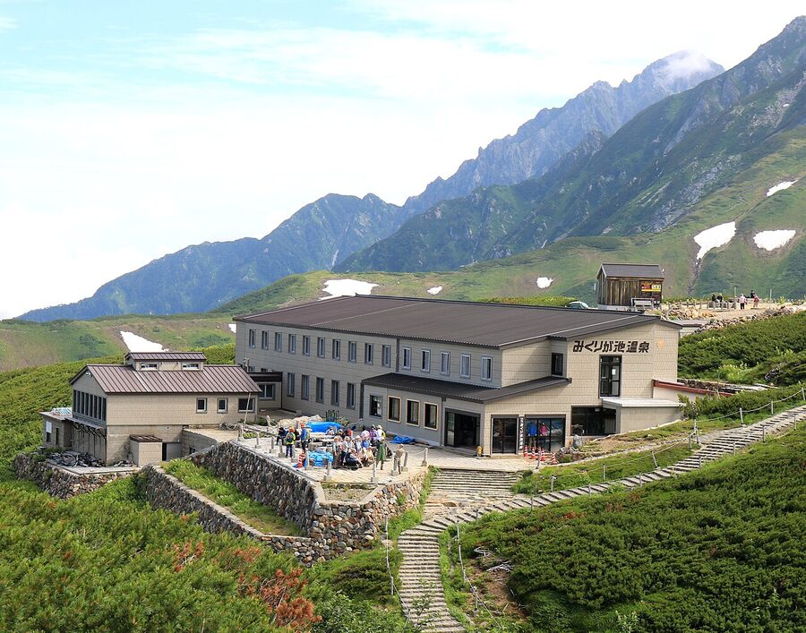
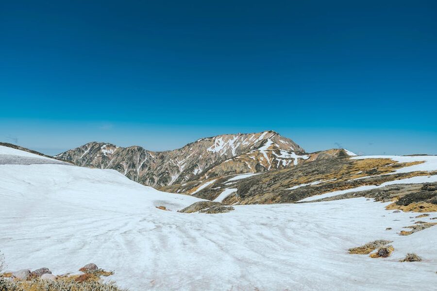
Murodo plateau: the part that earns the overnight
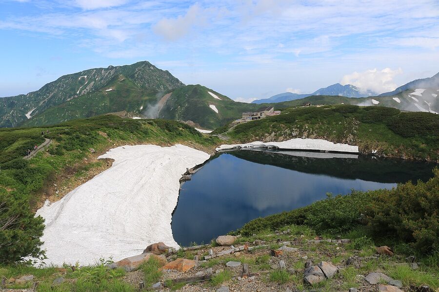
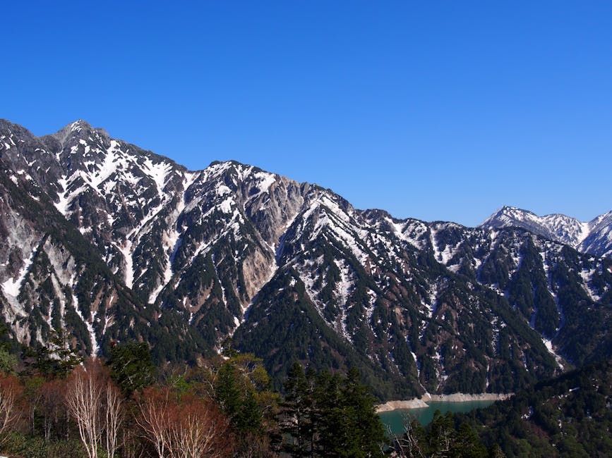
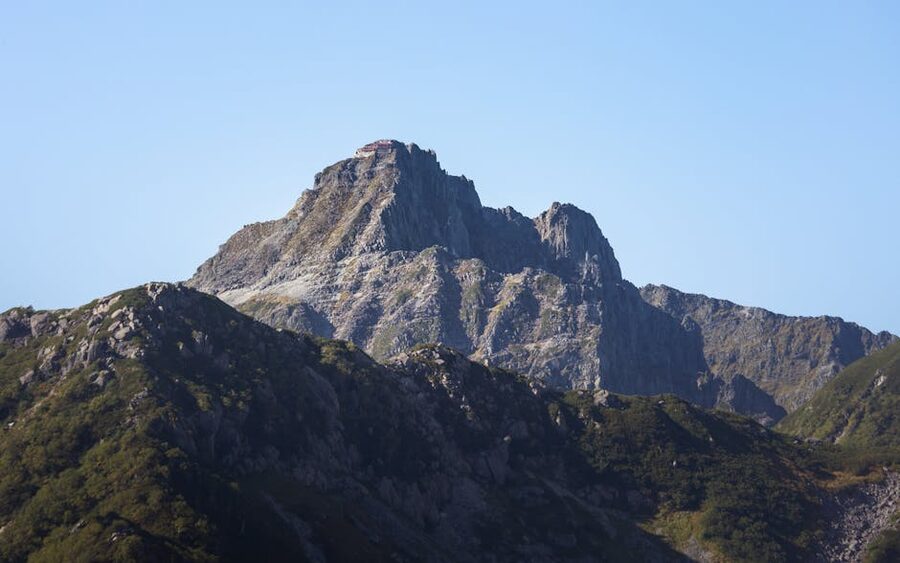
Murodo sits at 2,450 metres, technically the highest accessible station in the Northern Alps by public transport. It’s a glacial cirque ringed by 3,000-metre peaks: Tateyama itself (the Oyama summit at 3,003m), Bessan, Jodosan, and Tsurugidake to the north (the spiky one in every photograph). The terminal building has a hotel attached, a couple of restaurants, the Tateyama tourist office, and a second-floor observation deck the tour groups walk straight past.
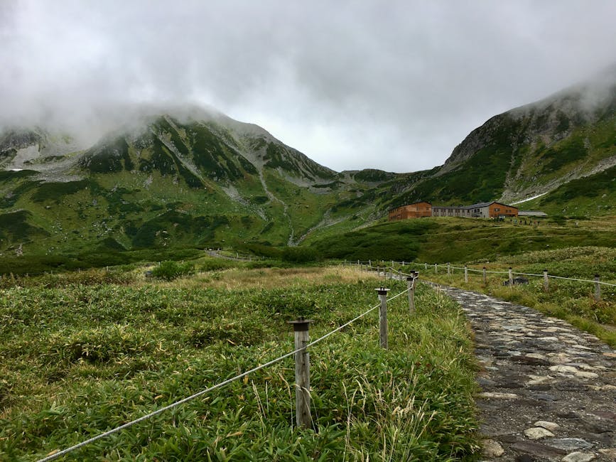
Between mid-July and late September, the plateau is flowered with alpine plants. Komakusa, chinguruma, kurumayuri, the lot. There are raichō (rock ptarmigan) on the walking trails if you’re early enough; they’re the official symbol of Toyama Prefecture and you’ll see signage about them in three languages. Several short loops give you the plateau in 2–3 hours: the Mikurigaike loop is the classic, taking in the crater pond, the small Murodo onsen building, and back to the terminal. Longer routes head to Jigokudani (‘Hell Valley’), a sulphur valley where the trail can be closed at short notice if volcanic gas concentrations rise.
Two practical things about Murodo most articles understate. First, the air is thin. 2,450m isn’t altitude-sickness-territory for healthy travellers, but you’ll notice the climb of the staircase to the second-floor observation deck more than you expect. Drink water, walk slow on day one. Second, the temperature gradient is brutal. It can be 26C in Toyama and 3C at Murodo on the same morning. A windproof shell, a fleece, and decent shoes are the minimum kit; in late April or May you also want gloves and a hat. I’ve seen tourists in T-shirts and trainers shivering at the snow corridor in May. The terminal sells emergency outerwear at terminal-shop prices; bring your own.
Where to stay at Murodo (while you still can)
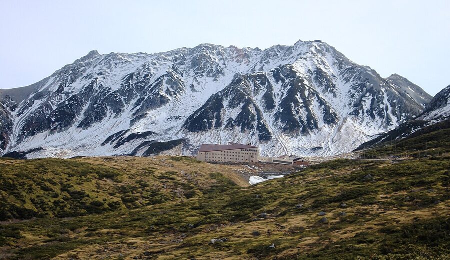
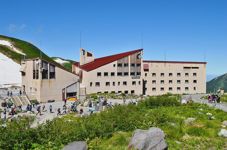
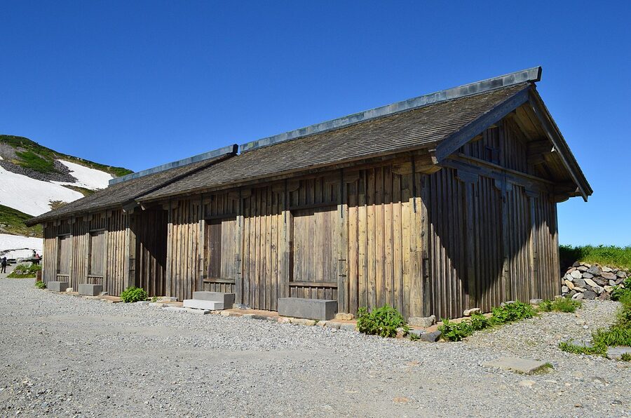
Hotel Tateyama is the obvious anchor: 2,450m, attached to the Murodo terminal, dinner-and-breakfast plan from ¥31,900 per person (basic plan) up to ¥68,200 (upgraded plan with Tateyama-view rooms). It’s a proper full-service mountain hotel with a Western dining room (Tsurugi), a Japanese dining room (Tateyama), a tea lounge and an alpine bar. You don’t need to walk anywhere from the terminal; reception is signposted inside the building. As of 2026 the hotel runs three guided activities for guests: a Mikurigaike walking circuit, a ‘Yuki-no-Otani’ guided walk during the snow corridor season (17:00 onwards, after the day visitors leave), and a star-watching evening that on the published 2026 calendar runs ten dates between mid-May and mid-August. Bookings via h-tateyama.alpen-route.co.jp. The hotel announced in July 2025 that the lodging service ends on 31 August 2026. The terminal facilities (shop, restaurant, day-use access) continue. If you want the up-here-overnight experience as Hotel Tateyama runs it, this season and 2026’s first eight months are the last chance.
Mikurigaike Onsen is the alternative: a smaller hut-hotel about 10 minutes’ walk from Murodo terminal, on the path to the pond it shares its name with. The onsen here is unusually high (the bath is the highest natural-spring bath in Japan), and the rooms are simpler and cheaper than Hotel Tateyama. Plan rates as of 2026 run roughly ¥13,000–18,000 per person with two meals. Mikurigaike Onsen also runs through the summer hiking season but, like Hotel Tateyama, is closed in winter; book via the official site mikuri.com. The walk over from the terminal is on a clear flagged path in summer, but if there’s still snow on the ground (any time before late June) you’ll want proper boots.
Midagahara Hotel, lower down the route at 1,930m, is the third option for a ‘stay on the mountain’ night. It’s a Highland Bus stop earlier than Murodo, with views over the Midagahara wetland and easier altitude than Murodo itself. Rooms run from around ¥18,000 with two meals.
Trolleybus to Daikanbo and the Tateyama Ropeway
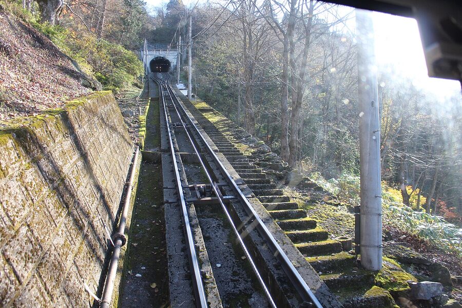
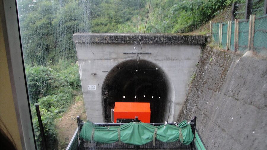
The Tateyama Tunnel Trolleybus links Murodo to Daikanbo in 10 minutes. As of 2026, this is the last operating trolleybus line anywhere in Japan; the parallel Kanden tunnel line on the Nagano side was converted to all-electric buses in November 2018 and only this one still runs on overhead-wire trolley power. Fare ¥2,200, the route is entirely inside a tunnel, and you’ll see nothing but tunnel wall and tunnel light for 10 minutes. The journey is about the engineering rather than the view; if rolling stock is your interest, this is one of the more notable artefacts of post-war Japanese transit history.
Daikanbo at 2,316m is the trolleybus terminus and the start of the ropeway. The station has a rooftop observation deck reached by a separate flight of stairs, signposted but easy to miss in the bustle of the transfer. From the deck you get a long axial view east towards the Kurobe valley and west back across the Tateyama range. Allow 15 minutes here even on a tight schedule; it’s the route’s best mid-traverse panorama and the one that justifies the steep section ahead.
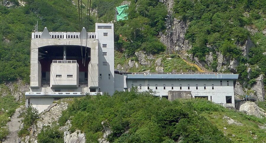
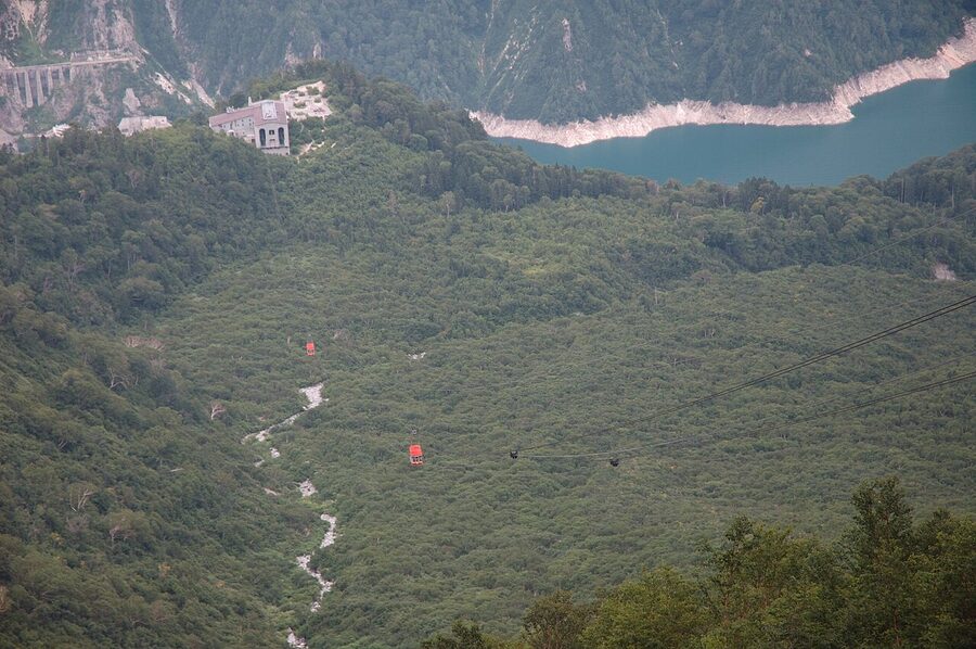
The Tateyama Ropeway is the showpiece of the descent. The cable runs 1.7 km between Daikanbo (2,316m) and Kurobedaira (1,828m) without a single support tower in between, Japan’s longest single-span ropeway, by some margin. The car holds 81 passengers and the trip is 7 minutes, with a fare of ¥1,700. Standing at the front-left as the car lifts off Daikanbo gives you the long view east into the Kurobe gorge and, on a clear day, the Tateyama range receding behind. This is one of the route’s two genuine wow moments (the other is the dam, coming up).
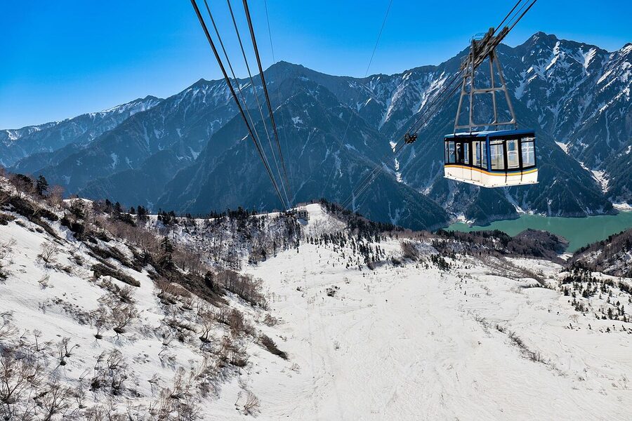
The capacity is also the route’s tightest bottleneck. 81 passengers per car, departures every 20 minutes, and a near-continuous stream of buses delivering trolleybus passengers at Daikanbo. On the busiest May days the queue can run 90 minutes. The Web Ticket reservation system handles the cable car at Tateyama Station but not the ropeway; the queue is on whoever shows up. Going Toyama-side eastbound, this is where staying overnight at Murodo or Mikurigaike Onsen pays a second dividend: catch the first ropeway down at 09:00 and you’re ahead of the day buses entirely.
Kurobe Cable Car and the Kurobeko approach
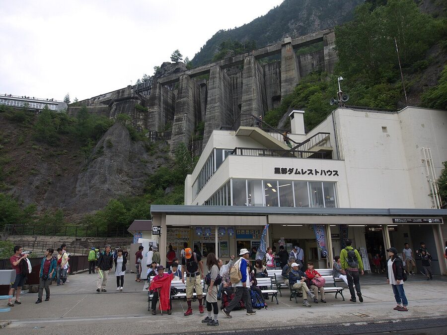
From Kurobedaira, the Kurobe Cable Car drops 373 metres into the valley to Kurobeko, the station beside Kurobe Dam. The trip is 5 minutes, ¥1,150, and the entire route is inside a tunnel: the only fully-tunnelled cable car in Japan. The reason is mostly avalanche protection; the slope above the line is steep and snow-prone. From Kurobeko you walk across the dam itself, which is the only segment of the through-route covered on foot.
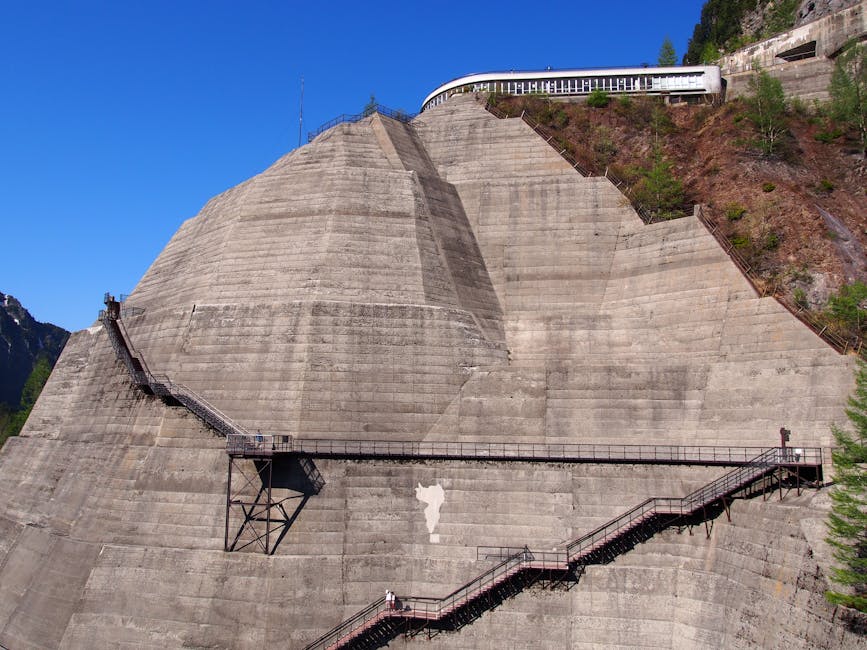
Kurobe Dam: 220 steps, then the discharge
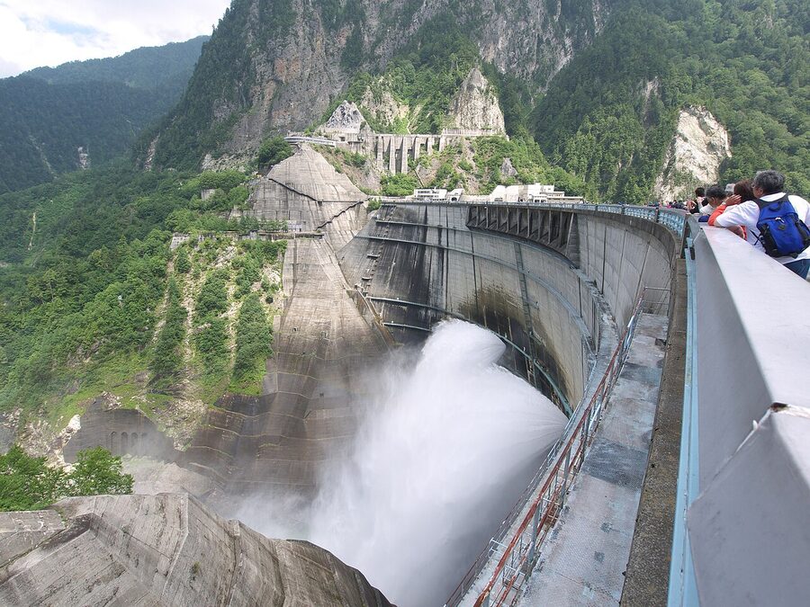
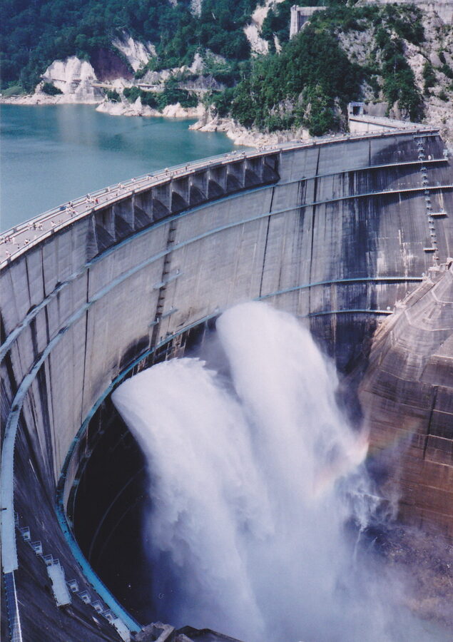
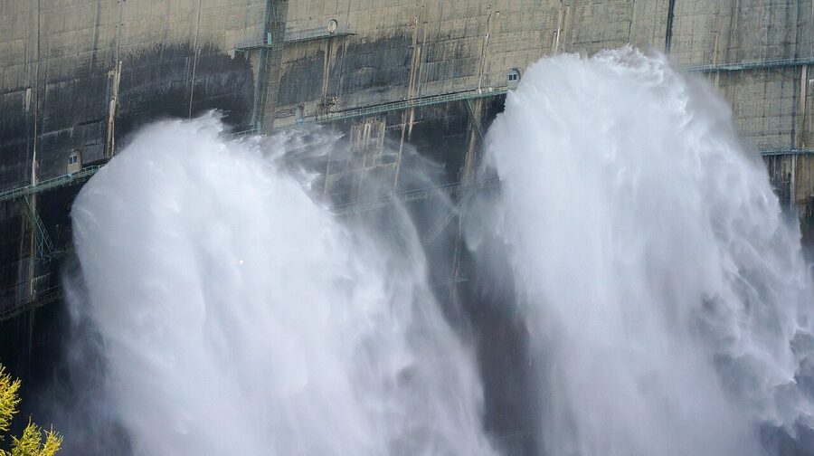
Kurobe Dam is the route’s second showpiece. 186 metres tall, Japan’s tallest dam, opened in 1963 after seven years of construction that cost 171 lives. The dam is operated by Kansai Electric Power and the hydroelectric plant beneath it supplies a substantial chunk of Kansai’s power. From the cable-car arrival at Kurobeko, you walk across the dam crest itself, a 15-minute traverse with the reservoir on one side and the 186-metre drop on the other. Structurally it’s an arch dam; the curve is what carries the load.
The dam observation deck is the bit guided tours skip and you absolutely should not. From the Kurobeko cable car arrival, follow signs for the Kurobe Dam observation deck (展望台). It’s a 220-step climb up a green stairway built into the canyon wall, open during the route’s operating season. Twenty minutes’ patience for the climb gets you a perspective of the dam wall and the discharge column from above, where the scale of the structure properly registers. The day-tour itineraries have 30 minutes at Kurobe Dam and the climb takes more than that, which is why you don’t see them up there.
The discharge spectacle is the other reason to time the trip. From 26 June to 15 October 2026, Kurobe Dam runs its tourist discharge for visitors. Up to 15 cubic metres per second pours from the dam outlet, and the spray throws rainbows across the gorge on sunny mornings. The discharge times for 2026 are: 26 June to 31 July, 06:00–17:30; 1 August to 10 September, 06:30–17:00; 11 September to 15 October, 07:00–16:30. Outside these windows the dam outlet is dry and visually a different (still impressive) thing entirely. If the discharge is on your list, mid-July through August is your best window for combining peak discharge with reliable Murodo weather.
Lodging at the dam: there’s no major hotel at Kurobeko itself, but Omachi Onsen, 25 minutes by bus from Ogizawa, has half a dozen ryokan and hotels at standard onsen-ryokan prices (¥15,000–25,000 per person with two meals). Staying here gives you a Nagano-side base for an early-morning return up to Kurobe Dam, before the day-traverse buses start arriving at 11:00. Kurobe Kanko Hotel at Omachi Onsen is the best of them; book via the standard channels.
The Nagano-side exit: Kanden bus and the bus to Shinano-Omachi
From the Nagano end of Kurobe Dam, the Kanden Tunnel Electric Bus takes you to Ogizawa in 16 minutes. Until November 2018 this was a trolleybus too; it converted to all-electric buses for the 2019 season, which means the route now has only the one trolleybus line (the Tateyama Tunnel one on the Toyama side). The fare is ¥1,800. The Kanden Tunnel goes through the Akazawa mountain spine and emerges at Ogizawa, the Nagano-side gateway and a substantial bus terminal in its own right.
From Ogizawa, the Ogizawa-Omachi route bus runs to JR Shinano-Omachi station in 40 minutes (¥1,650). There’s also a more direct express bus from Ogizawa to Nagano City in 105 minutes (¥4,300), useful if you’re heading back to Tokyo via the Hokuriku Shinkansen rather than the Azusa limited express through Matsumoto. Shinano-Omachi connects via the JR Oito Line to Matsumoto, and from Matsumoto to Tokyo via the Azusa limited express (3 hours total Shinano-Omachi to Tokyo, fully covered by the JR East pass).
The Kurobe Gorge Railway add-on: a different mountain
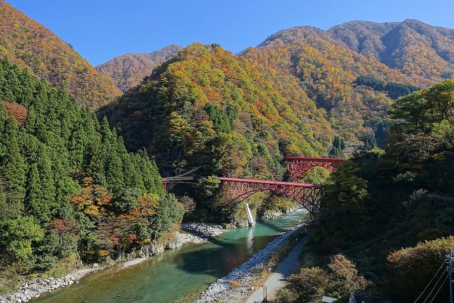
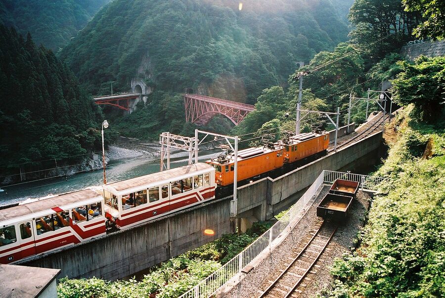
The Kurobe Gorge Railway is the Alpine Route’s underrated companion piece. It’s a separate operation entirely: a 20.1-km narrow-gauge line that runs from Unazuki Onsen, on the Toyama side at the lower end of the Kurobe massif, up the gorge to Keyakidaira. The trains were originally built to service the Kurobe River hydroelectric construction (the same project that produced Kurobe Dam) and have since been opened to passengers. The carriages are wood-bench open-sided affairs that you ride out of in the wind; the line crosses the gorge on a series of red-painted steel bridges that are the photographs you’ve seen of this railway. The 2026 commercial season opened on 20 April and runs to late November, broadly matching the Alpine Route window.
The fare structure is per-segment, with the full Unazuki to Keyakidaira ride at around ¥1,980 one way in standard open-sided carriages. Reservations can be made via the official Kurobe Gorge Railway site. The ride is roughly 1h 20m one way, and the most-photographed station is Kanetsuri, where there’s an open-air kawara-no-yu (river-bed onsen) you can soak in if you bring a swimsuit and walk down to the bank. The whole trip earns about half a day and pairs naturally with a night at Unazuki Onsen.
If you’re already on the Alpine Route, the practical add-on is: take the route from Toyama to Murodo, stay overnight at Murodo, traverse to Ogizawa and back via Murodo on day 2, then back to Toyama via Tateyama Station and overnight at Unazuki Onsen for the gorge railway on day 3. The downside is that this means the whole route is done as an out-and-back, which doubles the through-fare. The upside is that you actually see both sides of the same mountain. For travellers with three days and an interest in Showa-era engineering as much as alpine scenery, this is the version I’d recommend.
Mikurigaike, Jigokudani and the day-2 walking
If you stay overnight at Murodo, the morning is the one stretch of the route where you have the high country mostly to yourself. The first ropeway down doesn’t run until 08:00 and the day-traverse buses don’t deliver fresh visitors to the snow corridor until 09:30 or so, which gives you a clear two-hour window. Use it for the Mikurigaike loop, the easiest and most rewarding short walk on the plateau.
The route: walk out of Murodo terminal towards the snow corridor (clearly signposted), then turn left at the first junction onto the path marked Mikurigaike. The path is paved or board-walked the whole way; in early May it’s still partly under snow but cleared. 15 minutes’ walk gets you to the pond’s south end, with Mt Tate and Tsurugidake reflected on still mornings. Continue around the east side and the path drops to the small Mikurigaike Onsen building, then climbs back to the terminal via the north approach. Total distance is about 2 km and the loop takes 60–90 minutes depending on photograph stops.
For more ambitious walkers, the Jigokudani path drops below Mikurigaike into the sulphur valley (its name translates as ‘Hell Valley’ for the obvious reason) and back up to Murodo via a longer northern loop. The whole thing is around 3 hours. The catch: the Jigokudani path is occasionally closed at short notice when the volcanic gas concentration in the valley spikes, and the closure is non-negotiable. Check the day’s status at the Murodo information desk before setting out.
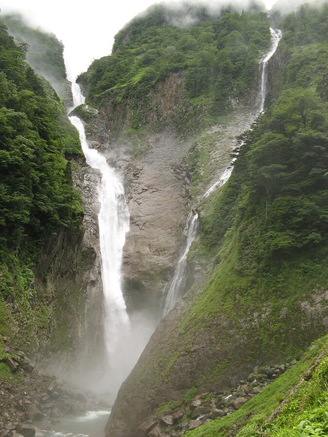
Shomyo Falls: the side trip Toyama side
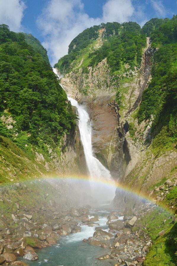
If you’ve based yourself in Tateyama town for a day before going up the route, the Shomyo Falls side trip is worth half a day. Shomyo-daki is the tallest waterfall in Japan, 350 metres from lip to basin, and in the spring snowmelt season (April through May) it’s joined by the seasonal Hannoki Falls on the same cliff face, the pair sometimes labelled Hannoki-Shomyo and reaching close to 500m of vertical water in good melt years.
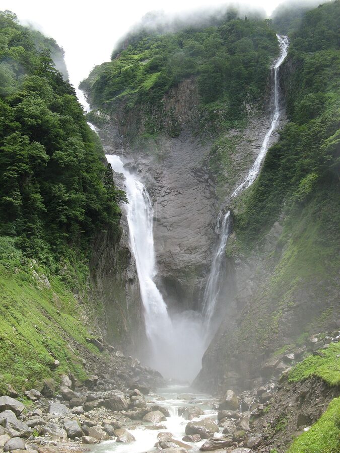
Access is by the Tateyama Township shuttle bus from Tateyama Station, running mid-April to late November in line with the Alpine Route season. The bus drops you at the trailhead, and the walking path to the falls viewing platform is 15–20 minutes each way on a graded gravel track. The platform sits across the gorge from the falls, which on the busiest days has a queue for the prime photo spot but is mostly serviceable. Take a waterproof: the spray reaches the platform when the volume is heavy.
What to wear: the temperature differential is the catch
This is the practical thing every first-time Alpine Route traveller underestimates. Tateyama town and Toyama at the bottom of the mountain are seasonal-normal Japan: 18–25C in May, warmer in summer. Murodo at 2,450m is anywhere between -5C and +10C across the operating season, with wind on top. The temperature differential between Toyama and Murodo at the same hour can be 25 degrees Celsius in May.
The minimum kit: windproof shell jacket; a fleece or insulated mid-layer; long trousers (not shorts, even in summer); proper closed shoes (trainers fine for the through-traverse, hiking boots for the Mikurigaike loop or longer); gloves and a hat for April and May trips and any October or November visit; sun cream and sunglasses (at altitude with snow reflection the UV is fierce). What people actually wear that fails: sandals on the snow corridor walking section, light cardigans without a wind layer, T-shirts at Daikanbo. The Murodo terminal sells emergency outerwear, but you’ll pay terminal-shop prices.
Add a small daypack with at least 1 litre of water per person and a snack. The terminal restaurants are fine but you may not want to time meals to convoy schedules.
Tickets and reservations: the Web Ticket question
The official ticket site (alpen-route.com) sells two relevant ticket types: Web Ticket and Same-Day Ticket. Web Ticket is the one to use if you’re going during peak season (15 April through end of May, peak autumn colour mid-October). It bundles the through-fare with a reservation slot for the Tateyama Cable Car (the first big bottleneck if starting Toyama-side) and the Kanden Tunnel Electric Bus (the equivalent if starting Nagano-side). The reservation guarantees you a specific departure time on those legs only. The cable car at Tateyama Station regularly sees 2-hour queues without one.
Same-Day Tickets are sold at Dentetsu Toyama, Tateyama, and Ogizawa stations and remain available even after Web Tickets have sold out for the day. The trade-off is no slot reservation, so on a peak weekend you may walk in to a terminal and find the next available cable car is in 90 minutes. For shoulder-season trips (June, September) Same-Day is fine. For Golden Week and the snow corridor weekends in late April and early May, Web Ticket is essentially mandatory.
The route also accepts the Alpine-Takayama-Matsumoto Area Tourist Pass, a JR Central / TKK joint product that bundles the Tokaido Shinkansen access from Nagoya, the local rail to Toyama, the full Alpine Route through-fare, and the post-traverse Matsumoto leg. It’s good value if you’re combining this with Takayama and Matsumoto in one trip. Less useful if you’re approaching from Tokyo, where the Hokuriku Shinkansen + standard JR Pass + Web Ticket combination usually works out better.
Combining with the rest of Hokuriku
The Alpine Route fits naturally into a 5- to 7-day Hokuriku itinerary. The shape that works: Tokyo to Toyama by Hokuriku Shinkansen on day 1, Tateyama Cable Car and overnight at Murodo on day 2, traverse to Ogizawa on day 3, drop down to Matsumoto via Shinano-Omachi on day 3 evening, then Matsumoto and Kamikochi on day 4. Alternatively, a Hokuriku-side circuit: Toyama to Tateyama and overnight at Murodo on day 2, traverse and back across via Murodo on day 3 (so the through-fare doubles), then Toyama to Kanazawa on day 3 evening for two nights, with Shirakawa-go as a day trip from Kanazawa on day 5.
If you’re doing the wider region, the Hokuriku regional guide covers the post-Alpine extensions: Toyama City for the firefly squid season in spring, Kanazawa’s Kenrokuen and Higashi Chaya districts (worth two full days of its own), the World Heritage gassho-zukuri farmhouses at Shirakawa-go, and Eiheiji’s zen monastery in Fukui. The Kanazawa walking guide details the city in detail; the Shirakawa-go guide covers the gassho villages and the winter light-up event for travellers planning a January or February trip.
For winter context across the region, the snow scenery roundup places the Alpine Route’s snow corridor alongside the other major snow viewing destinations. Worth reading if Yuki-no-Otani is your hook for Japan and you’re picking between options.
What I’d actually do: a 3-day plan that earns its name
If I had three days and the choice, this is what I’d do.
Day 1: Tokyo to Toyama, then up to Murodo. 09:00 Hokuriku Shinkansen Tokyo to Toyama, arrive 11:12. Toyama for lunch (Sushi Saiun for kaisendon, walking distance from the station). 14:00 Chitetsu local to Tateyama, arriving roughly 15:00. Web Ticket reservation for the 15:30 Tateyama Cable Car. Bijodaira at 15:37. 30-minute Bijodaira cedar loop. 16:30 Highland Bus to Murodo. Murodo by 17:20. Check into Hotel Tateyama or walk over to Mikurigaike Onsen for the night.
Day 2: Murodo morning, traverse, evening at Omachi. Up at 06:30 for the Mikurigaike loop while the plateau is empty. Back to Murodo terminal for breakfast. 09:00 first Tateyama Tunnel Trolleybus to Daikanbo, ahead of the day-traverse arrivals. 09:30 ropeway down to Kurobedaira. 10:00 Kurobe Cable Car to Kurobeko. 10:30 walk across Kurobe Dam, climb the 220 steps to the observation deck (45 minutes there and back), discharge in season. 12:30 Kanden Tunnel Electric Bus to Ogizawa. 13:30 Ogizawa-Omachi bus to Shinano-Omachi. Check in at Omachi Onsen for the night; afternoon and evening at the onsen ryokan.
Day 3: Matsumoto and onwards. 09:00 JR Oito Line Shinano-Omachi to Matsumoto. Matsumoto Castle in the morning. 12:30 Azusa limited express Matsumoto to Shinjuku, arriving roughly 15:30. The day’s enough buffer for the train back into Tokyo, or the Azusa connects neatly through to Hakuba if you’ve added a Northern Alps stop on the back end.
This version costs the same fare as the day-traverse and adds two nights of lodging (¥30,000–50,000 for Hotel Tateyama, ¥15,000–25,000 for an Omachi Onsen ryokan) plus the food. For a one-time visit to a route that’s been running for 55 years and won’t have its highest-up hotel after August 2026, that’s the proportionate amount of time and money to spend.
The closing notes nobody mentions
Two minor things travel pieces tend not to flag.
First, baggage. The route runs through a chain of cable cars and ropeways with limited under-seat storage and small terminal lockers. If you’re carrying full suitcases, the official baggage forwarding service (Carry Service) ships your luggage from Tateyama Station to Ogizawa for around ¥2,500 per case. Worth it. Don’t try the route with a 28-inch wheeled case; the Bijodaira cable car corridor and the Daikanbo ropeway approach are physically tight.
Second, weather. The upper sections of the route close not infrequently in early-season storms. April and early May trips have a 5–10% chance of a partial closure due to weather; a website check on alpen-route.com on the morning of travel is wise. The Highland Bus is the leg that closes first, usually because the Tateyama Snow Wall road is unsafe in fresh snow. If you find yourself stranded at Bijodaira, the cable car back down is your fallback; the route fare allows reverse direction in the same day at no extra charge.
The Alpine Route was opened in 1971 to connect a hydroelectric construction project to the wider tourism economy of the Northern Alps. Fifty-five years later it remains one of Japan’s more extraordinary engineering and tourism propositions: an actively-managed, infrastructure-dependent crossing of an alpine watershed that’s closed off to private vehicles by design. The version that drives a tour bus from Toyama to Shinano-Omachi in seven hours treats it as a sightseeing checklist. The version that stays overnight on the mountain treats it as the high-country route it actually is. They cost the same per kilometre. They’re not the same trip.
_-_Flickr.jpg)
.jpg)
_at_Bijodaira_Station_20110515.jpg)
.jpg)